|
|
|
|
Harbor Defenses of Sitka, Alaska |
|
|
|
LOCATION : St. Lazaria Island (Fort Babcock) |
|
|
|
|
|
|
|
|
|
|
|
|
|
|
|


|
|
SCR-296 for Battery 290 The SCR-296 targeting radar for Battery 290 and its support facilities were completed on St. Lazaria Island. The SCR-296 was placed atop a 75 foot steel tower and the antenna was disguised as a water tower. A radar operators building and a power house were also completed. The radar and its tower were dismantled in 1944 when construction of Battery 290 at Shoals Point was halted. The base end station, signal station No. 1, and searchlights No. 5 & 6 were not built. The base end station was planned to be a two-room concrete structure. |
|
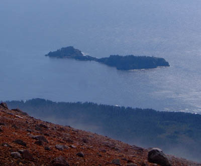
St. Lazaria Island from the south rim of Mt. Edgecumbe - August 23rd, 2003 |
|
|
|
The island has been part of the Alaska Maritime National Wildlife Refuge since 1909. The island is home to hundreds of thousands of seabirds that nest on the island. The radar site is very overgrown. There are bird burrows surrounding the site and between the tower supports. In addition to the four tower supports and operator's building, there is a large wooden building, a Quonset hut, and a smaller wooden building that have all collapsed. The small wooden building has a lot of steel cable around it, so it could have housed a motor to carry supplies up to the radar site from the beach 200 feet below. I did not find a power building for the radar. |
|
|
Photos and additional information: |
|
|
Recent Photos of the SCR-296 radar site |
|
WWII
Era Photos
Photos of St. Lazaria Today |
|
|
|
|
|
|
|
|
|
|
|
|
|
|
|
|
|