|
|
|
|
Harbor Defenses of Sitka, Alaska |
|
|
|
LOCATION : Harbor Mountain |
|
|
|
|
|
|
|
|
|
|
|
|
|
|
|
|
|
|
|
Harbor Defenses of Sitka, Alaska |
|
|
|
LOCATION : Harbor Mountain |
|
|
|
|
|
|
|
|
|
|
|
|
|
|
|
|
These Photos are from June 2004 |
|
|
|
|
|
|
|
|
This is a view of the collapsed Anti Aircraft Artillery Intelligence Station (AAAIS) tower. |
|
Another view of the AAAIS tower |
|
|
|
|
|
|
|
|
|
AAAIS tower |
|
This is a pile of gravel from Indian River. The Army used Indian River gravel in all of the concrete construction in the Sitka area. Note the SCR-271 radar site on the hill. |
|
|
|
|
|
|
|
|
|
This si a view looking north from the AAAIS site. Notice the SCR-271 radar site. |
|
This is another view of the radar site from the AAAIS site. |
|
|
|
|
|
|
|
|
|
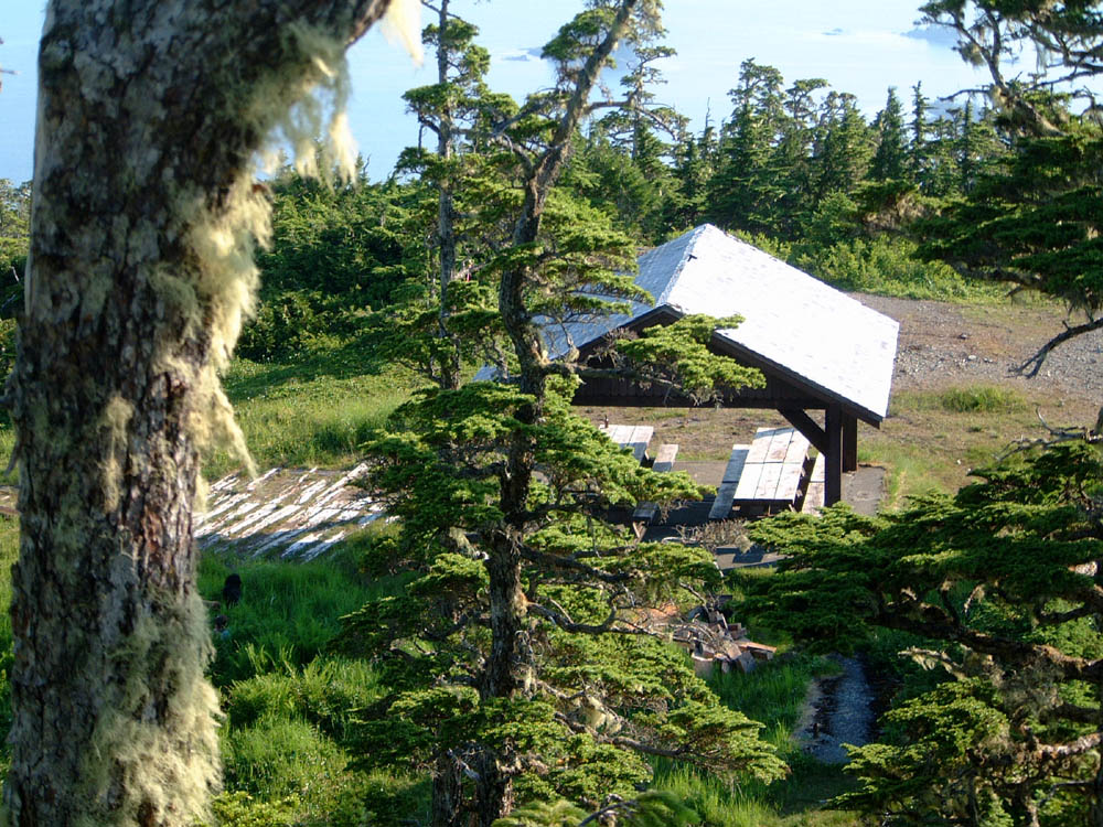
The Harbor Mountain USFS picnic shelter is built on top of the SCR-271 radar building and tower foundation. |
|
The SCR-271 radar site. Note the original corduroy road. |
|
|
|
|
|
|
|
|
|
The SCR-271 site from the anti-aircraft machine gun tower site. |
|
The SCR-271 site from the anti-aircraft machine gun tower site. |
|
|
|
|
|
|
|
|
|
The SCR-271 radar position. Note the concrete pad for electrical equipment in the foreground. |
|
|
|
|
|
|
|
|
|
|
|
This is the remains of the supply building. |
|
Another view of the supply building |
|
|
|
|
|
|
|
|
|
Close up of the electrical conduits |
|
The supply shed is slowly becoming overgrown. |
|
|
|
|
|
|
|
|
|
One of the concrete pads next to the radar position |
|
This is the bigger of the two concrete pads by the radar building. |
|
|
|
|
|
|
|
|
|
The latrine holes are still very obvious on the hill near the Quonset hut sites and supply building site. |
|
This is the WWII era path from the Quonset huts and supply building back to the radar site. |
|
|
|
|
|
|
|
|
|
The power building foundation is located at the end of the Harbor Mountain road, still a half-mile further than the radar site. |
|
One of the two Quonset hut sites. |
|
|
|
|
|
|
|
|
|
Two generator positions are clearly discernable on the power building foundation. |
|
There is another view of the power foundation. |
|
|
|
|
|
|
|
|
|
|
|
|
|
|
|
|
|